

13 min read
In this article
- Dubai 2040 urban master plan in short
- What is the Dubai 2040 Urban Master Plan?
- The eight goals of the Dubai 2040 urban master plan, in everyday words
- Urban centres in the Dubai 2040 master plan and growth around metro stations
- Housing, parks and public spaces
- From the Dubai urban plan 2040 to your plot
- Plans, guides and rules: what is binding?
- Planning standards for public services
- What the Dubai 2040 urban master plan means for your villa and a future annex or majlis
- Practical steps before you build
- Official sources and the Dubai 2040 master plan PDF
- Frequently asked questions
- What is the Dubai 2040 urban master plan?
- Does the Dubai 2040 master plan change the rules for building an annex or majlis?
- What are the goals of the Dubai urban plan 2040?
- What are the urban centres in the Dubai 2040 plan?
- What are the public services planning standards in decision 260/2019?
- Where can I find the Dubai 2040 master plan PDF?
- Is the TOD manual a binding rule for my villa?
- Does every area of Dubai follow Dubai Municipality planning?
- Planning an annex or majlis in Dubai?
The Dubai 2040 Urban Master Plan is the city's long-range map for where homes, parks, jobs and transport should grow. If you own a villa and are thinking about an annex, a majlis or an extension, this guide explains in plain language what the plan sets out, which related Dubai Municipality guides sit beneath it, and what it does and does not change for your own plot.
Dubai 2040 urban master plan in short
- The Dubai 2040 urban master plan is a strategic plan with 8 goals and 34 spatial policies. It guides the city as a whole; it is not a permit checklist for a single villa.
- Its themes will be familiar to any family: more parks and open space, healthier neighbourhoods, safer walking and cycling, housing choices for citizens, and protection of heritage.
- Related guides add detail: the public services planning standards (adopted by administrative decision 260/2019), the Transit Oriented Development manual, and area guides such as the one for Hatta.
- Policy documents are plans and guides. Decision 260/2019 gives the planning standards guide its force, and the TOD manual says it carries mandatory parameters inside TOD zones.
- For an annex or majlis, your plot conditions and the Building Code still decide what you can build. Ask Dubai Municipality (DM) to confirm both before you design.
What is the Dubai 2040 Urban Master Plan?
DM's Executive Summary of the Dubai Urban Plan 2040 presents the Dubai 2040 master plan as the sixth urban plan in Dubai's history, after plans in 1960, 1971, 1985, 1995 and 2012, with an urban development framework in 2008 in between. It is a long-range map that guides future urban and population growth and sets spatial strategies to improve quality of life while making the best use of land and infrastructure.
The scale of change explains why such a plan is needed. The summary lists a population of about 40,000 in the first plan and 3,355,900 in the sixth, with an urban area of 1,490 km2, and states that population has grown roughly 80 times and built-up urban area roughly 170 times since the first plan.
The plan was prepared in phases: analysis of the current situation, development of the vision (including estimates of population and workforce to 2040 and their land and infrastructure needs), a structure plan, governance of urban planning, and finally statutory plans meant to make sure the strategic plan is carried out.
The eight goals of the Dubai 2040 urban master plan, in everyday words
The vision quoted in the summary is "Dubai, the best city in the world to live in". Its eight goals are:
- Make the best use of land and infrastructure resources.
- Plan healthy, lively communities.
- Provide more parks and open spaces.
- Improve access with a people-centred approach.
- Improve the economic effectiveness of land through spatial integration.
- Improve the quality and resilience of the environment.
- Protect heritage, antiquities and landmarks of cultural value.
- Apply spatial planning and regulations.
Urban centres in the Dubai 2040 master plan and growth around metro stations
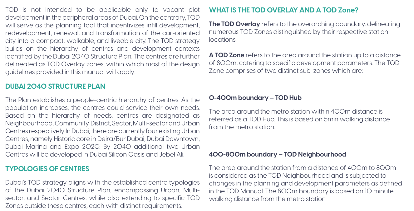
A key idea is a hierarchy of centres, so that residents can meet more of their daily needs close to home. According to DM's Transit Oriented Development (TOD) manual, the 2040 structure plan sets centres at six levels: Neighbourhood, Community, District, Sector, Multi-sector and Urban. Four Urban Centres exist today (the historic core in Deira and Bur Dubai, Downtown, Dubai Marina and Expo 2020), and two more are planned by 2040 (Dubai Silicon Oasis and Jebel Ali).
One of the plan's spatial policies gives priority to development around metro and transit stations. The TOD manual turns that into a zone of up to 800 m around a station (a 10-minute walk): a TOD Hub within 400 m and a TOD Neighbourhood from 400 m to 800 m. The manual says it is not only a design guideline: it contains both mandatory and flexible parameters, and inside a TOD Overlay its targets supersede the previous planning requirements. Some locations are exempt from the density increase, among them National Housing, conservation areas and historical buildings.
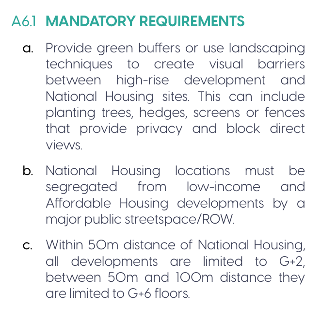
One rule matters to neighbours of citizen housing: for new developments near National Housing locations (the manual's term), buildings within 50 m are limited to G+2 and those between 50 m and 100 m to G+6, with green buffers and few openings facing the housing. If your villa is close to a metro station, ask DM whether a TOD zone applies to your plot.
Housing, parks and public spaces
The 34 spatial policies cover housing, jobs, community services, heritage, environment, mobility, utilities and governance. The ones most relevant to a family neighbourhood are:
- Housing: providing housing choices for citizens and promoting affordable housing.
- Parks and recreation: public parks and a high-quality recreation system; protecting natural reserves and ecological corridors; looking after marine frontages and waterways.
- Climate comfort: improving air, water and noise quality and reducing the urban heat island; managing rainwater and flooding.
- Community services: fixing shared locations for community services inside centres, with access to health, safety and emergency services.
- Streets: promoting safe streets suited to walking and cycling.
- Heritage: preserving historic and modern heritage.
The same Dubai 2040 family includes a Public Beaches Guide (Dubai 2040 initiative, 2023 to 2040) prepared by DM's urban planning and quality of life section.
From the Dubai urban plan 2040 to your plot
The figure below shows how the layers relate. The city plan sets direction, guides add detail for certain areas or topics, and your own plot is governed by its conditions and the permit process.
Plans, guides and rules: what is binding?
Not every document carries the same weight, and it helps to know which is which.
| Document | What it covers | Status as the documents describe it |
|---|---|---|
| Executive Summary of the Dubai Urban Plan 2040 | Vision, goals, strategic directions, 34 spatial policies | Strategic policy document |
| Public services planning standards guide | Site sizes and service ranges for mosques, schools, parks and similar services | Adopted by administrative decision 260/2019 |
| TOD manual | Planning and design around metro and tram stations | DM manual with mandatory and flexible parameters inside TOD zones |
| Hatta urban design and public realm guidelines | Character and design of development in Hatta | Described by the document as a non-statutory design guide |
The decision numbered 260 of 2019 is the one that gives the planning standards force: public and private bodies in Dubai must apply the adopted guide when planning, approving and carrying out urban projects, as a complement to Local Order 2 of 1999 on classifying land uses. Where a rule affects your plot directly, it normally comes from the Dubai Building Code, the plot's land use and the conditions DM issues. See our guides to the Dubai Building Code for villa annexes and to the building permit for a villa annex.
Planning standards for public services
DM's list of planning standards for public services (edition 2, dated 18 July 2019, the same date as decision 260/2019) is the practical side of "complete neighbourhoods". For low-density areas (under 70 persons per hectare), the table sets how much land and what walking range each service needs. A few examples from the list:
- Every 2,000 residents: a mosque for daily prayers (minimum site 1,800 m2, 500 m range) and a family park (minimum site 4,000 m2, 400 m range).
- Every 6,000 residents: a Friday mosque (minimum site 4,500 m2, 1,000 m range), a nursery, a kindergarten and a primary school (minimum site 8,000 m2, 800 m range).
- Larger catchments: intermediate and secondary schools, a government health centre, civil defence, library and police stations.
The list notes that some services can sit inside multi-use buildings and that some are optional. These standards guide the planners and developers who lay out neighbourhoods; they do not ask a villa owner to provide a park on a private plot.
What the Dubai 2040 urban master plan means for your villa and a future annex or majlis
Honest answer: nothing in the documents we reviewed says the Dubai 2040 urban master plan changes the rules for adding an annex or majlis to an existing villa. Those rules sit in the Building Code, your plot's conditions and DM's permit procedures. What the plan changes is the neighbourhood around you over time:
- More parks, shaded and walkable streets, and community services grouped in centres.
- Denser, mixed-use development near metro stations and in major centres, with specific limits next to National Housing locations.
- A stronger focus on heritage and on how new buildings sit within their area.
This is useful when you decide how to use your plot. A well-planned annex or outdoor majlis works with the climate and the street: shade, good insulation and a design that respects privacy. Our guides on external majlis design ideas and on Al Safat green building and insulation cover this from the building side.
Practical steps before you build
- Check your plot with DM. Confirm the land use, the building conditions and whether any TOD zone or area guide applies. Some areas of Dubai follow other authorities, such as free zones or master developers, so confirm who approves your area.
- Design to the Building Code. Plot coverage, height and setbacks come from DM's conditions and the Code.
- Apply for the permit. For a small project such as an annex or majlis, a supervising consultant is not mandatory during execution, but a consultant or engineering office may take part in the design and permit stage. Our permit guide explains the steps.
- Build with the right inspections. The DM engineer inspects before the foundations are poured, and pouring waits for approval; the same applies before a concrete roof slab is poured. A sandwich-panel roof has no pour, so the slab inspection does not apply to it. See the inspections and completion certificate guide.
A professional contractor works alongside you through these steps. Our 12-point checklist for agreeing a contract and the guide to approved materials and contractors help you set up a clear agreement. For costs, see the annex cost guide and try the free cost calculator. If a building already exists without a licence, read how to license an existing annex and the guide to building violations. MBRHE beneficiaries can start with the MBRHE annex and majlis guide.
Official sources and the Dubai 2040 master plan PDF
The links below lead to DM's official pages, where you can open the Dubai 2040 master plan PDF (the Executive Summary) and the guides mentioned above.
- Executive Summary of the Dubai Urban Plan 2040 (Dubai Municipality)
- Administrative Decision No. (260) of 2019 adopting the Guide of Planning Standards for Public Services in the Emirate of Dubai
- List of Planning Standards for Public Services (Dubai Municipality)
- Dubai Transit Oriented Development (TOD) Manual (Dubai Municipality)
- Hatta Urban Design and Public Realm Guidelines (Dubai Municipality)
- Public Beaches Guide, Dubai 2040 Initiative (Dubai Municipality)
- Local Order No. (2) of 1999 on classifying and codifying land uses in the Emirate of Dubai
- Dubai Urban Plan 2020 (the earlier plan, Dubai Municipality)
Frequently asked questions
What is the Dubai 2040 urban master plan?
It is Dubai Municipality's long-range urban plan, the sixth in the city's history. It sets a vision, eight goals and 34 spatial policies to guide where housing, jobs, services, green space and transport develop, aiming to make Dubai the best city in the world to live in.
Does the Dubai 2040 master plan change the rules for building an annex or majlis?
Not directly, as far as the documents we reviewed show. It is a strategic plan. The rules for your annex or majlis come from the Dubai Building Code, your plot's conditions and DM's permit process, so confirm them with DM before you design.
What are the goals of the Dubai urban plan 2040?
Eight goals: best use of land and infrastructure, healthy lively communities, more parks and open space, people-centred access, more effective economic use of land through spatial integration, better environmental quality and resilience, protecting heritage, and applying spatial planning and regulations.
What are the urban centres in the Dubai 2040 plan?
DM's TOD manual describes six levels of centres from Neighbourhood to Urban. The four existing Urban Centres are the historic core of Deira and Bur Dubai, Downtown, Dubai Marina and Expo 2020, with Dubai Silicon Oasis and Jebel Ali planned by 2040.
What are the public services planning standards in decision 260/2019?
Decision 260/2019 adopts DM's Guide of Planning Standards for Public Services, and DM's list of standards sets minimum site areas and service ranges for services such as mosques, parks, schools and health centres per population size. The decision requires public and private bodies in Dubai to apply the adopted guide when planning and carrying out urban projects.
Where can I find the Dubai 2040 master plan PDF?
DM publishes the Executive Summary of the Dubai Urban Plan 2040 on its website, and the links are listed under Official sources above together with the related guides. The official DM website and the current versions of the documents prevail.
Is the TOD manual a binding rule for my villa?
The manual says it contains both mandatory and flexible parameters, but it applies to development within TOD zones around metro and tram stations (up to 800 m). If your villa is near a station, ask DM whether your plot falls inside a TOD zone.
Does every area of Dubai follow Dubai Municipality planning?
Some areas of Dubai, such as free zones or master-developer communities, follow other authorities rather than Dubai Municipality. Ask DM or your community developer who approves your plot before you start.
Note: this article summarises official Dubai Municipality documents for owners. It is not legal advice, and the official DM website and the current versions of the documents prevail.
Planning an annex or majlis in Dubai?
If you would like a second pair of eyes on your idea, message us on WhatsApp or through the contact page. We can talk through your plot, the permit steps and the options, and you can browse our completed projects and services at your own pace.
Planning your next project?
Talk to the Al Mustafa team for advice and a quotation for your project in the UAE.
Related articles
 15 November 2026Building an Annex or Majlis with MBRHE Support: A Practical GuideRead article
 8 November 2026Building a G+4 or G+6 residential building in Dubai: requirements and stepsRead article
 1 November 2026Dubai Building Code explained: what villa owners and annex builders need to knowRead article